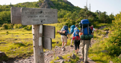
The 8 North Carolina Hiking Trails with Waterfalls
North Carolina is a great vacation spot for hikers as it is one of the most beautiful places on earth and heaven for hikers. Western North Carolina is blessed with over a million-acre of national forest, national parks, state parks, and other public lands. The Pisgah and Nantahala National Forests comprise most of this land and offer great opportunities for outdoor activities.
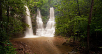
What makes these forests even more special is that they have several waterfalls that make it an even rewarding place to hike. There are literally hundreds of waterfalls and miles of hiking trails in this area. Western North Carolina is full of waterfalls. Literally 100s of them are scattered around the mountains of western NC.
So if you are planning a hiking trip to North Carolina in your mind, here are some of the best hiking trails with waterfalls.
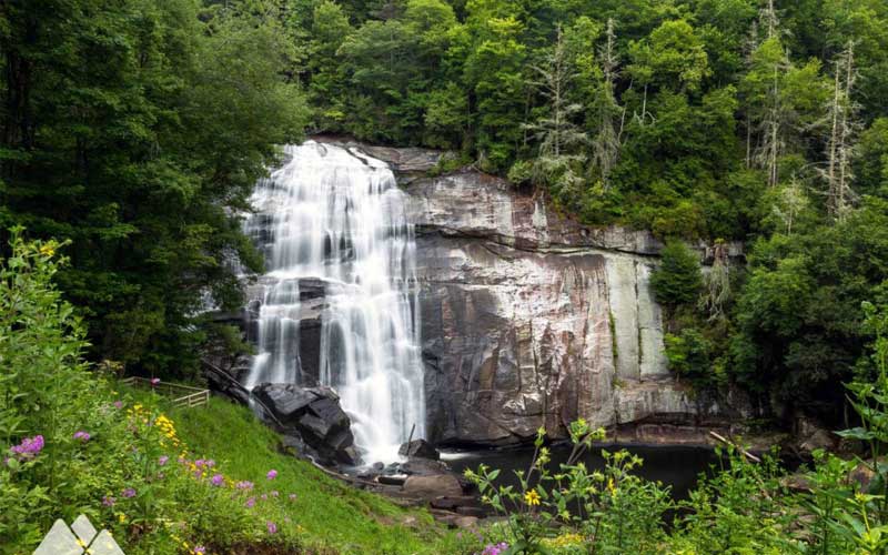
1. Moore Cove Falls Trail
- Waterfall Height: 50-feet
- Distance: 1.2-mile round trip
- Level: Easy
- Elevation Gain: 154-feet
Moore Cove Falls is a showery plunging waterfall located in one of the most popular areas of the Pisgah National Forest near the Davidson River in Transylvania County which is called the “land of waterfalls”. It is a 50-foot free-falling waterfall in a scenic creek-valley filled with fern and rhododendron. It is among the few waterfalls you can walk behind.
The trail to the Moore Cove Falls is a 1.2-miles roundtrip which makes it a good family-friendly waterfall hike. It’s also easy enough for families with small children to complete. It’s a delightful, beautiful walk through fern-filled woods. Trees such as oak, maple, tulip poplar can be seen along with dark, lacy hemlocks. This waterfall is highly recommended and it can also be combined with another nearby hike should you want to add some more miles to your day.
In late 2011, almost all obstacles from the surface were eliminated and the entire trail was re-graded providing sturdy wood structures for all creek crossings. The trail is located just off US 276 between Brevard and the Blue Ridge Parkway. The waterfall sits in a secluded, quiet cove set back from the highway, quiet refuge in an area popular with waterfall tourists. Sliding Rock and Looking Glass Falls are also nearby.
2. Hickory Nut Falls Trail
- Waterfall Height: 404-feet
- Distance: 1.5-mile round trip
- Level: Easy
- Elevation Gain: 295-feet
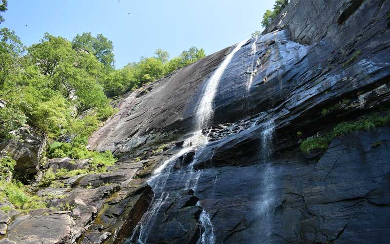
Hickory Nut Falls is one of the highest waterfalls east of the Mississippi River. This waterfall located in the Chimney Rock State Park has an impressive height of 404-feet. The view is rewarding when you stand at the base of this tall natural wonder. The water flow varies depending on rainfall. The flow is impressive after a rainfall, however, it only reduces to a small stream during dry periods.
The valley in the village of Chimney Rock also gives you a view of the Hickory Nut Falls on the cliff of the rock. It was featured in the film, “The Last of the Mohicans”. It a cool, refreshing stop, and a must-see if you happen to visit Chimney Rock.
The 1.5-mile round-trip hike is a beautiful walk through hardwood forests by rock cliffs. You’ll travel along the base of the cliffs that form the edge of the Hickory Nut Gorge and the Falls. Trees along this trail are large and interpretive signs help you identify points of interest in geography and ecology.
You must purchase a ticket to Chimney Rock at Chimney Rock State Park to hike to the waterfall. At the base of Hickory Nuts Falls, you can enjoy a splash of cold water on a hot day or perhaps you can simply enjoy the beauty of this towering waterfall.
3. Crabtree Falls Trail
- Waterfall Height: 70-feet
- Distance: 2.6-mile loop
- Level: Moderate
- Elevation Gain: 577-feet
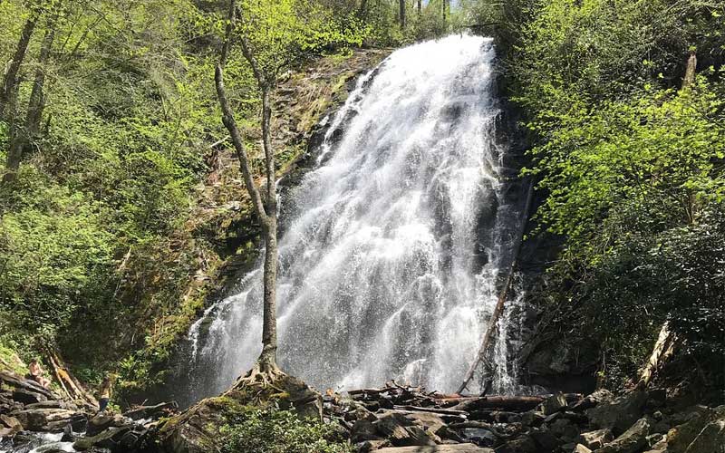
Crabtree Falls is one of the most photogenic falls in the area. The trail to the falls is a popular short loop that descends on a moderate path to this majestic 70-foot waterfall. Crabtree falls over a towering, sheer cliffs, forming one of Western North Carolina’s most beautiful waterfalls.
The hike departs from a trailhead near the Crabtree Falls Campground visitor center. It is a terrain filled with wildflowers, clear-flowing creeks, and scenic hardwood forests and is a great hiking area directly off the Blue Ridge Parkway north of Asheville.
Apart from being the starting point of the trail, the Blue Ridge Parkway makes a good base camp for further explorations into the area. During the summer, the trail is crowded, but you are likely to have it all to yourself if it is winter, especially if the gate is closed.
The trail to the falls has a length of 0.6-miles and 1.9-miles back from the falls to the campground which makes it something like 2.5 to 2.6-mile loop. The only strenuous sections are either side of the falls where the trail climbs steeply up and down the ridge. Apart from that, it is a leveled track that is relatively easy to hike. The trail is accessible year-round.
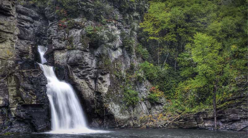
4. Linville Falls Trail
- Waterfall Height: 90-feet
- Distance: 1-1.6-miles depending on the route
- Level: Moderate to strenuous depending on the route
- Elevation Gain: 82-feet
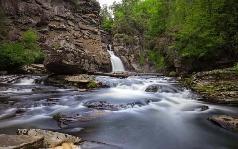
Linville Falls drops 90-feet into the 12-mile long Linville Gorge with tall cliffs above the river. Linville Falls is the most popular waterfall in the Blue Ridge Mountains because of its accessibility to the Blue Ridge Parkway. It is probably the most photographed waterfall in North Carolina as well. The waterfall is located on the Blue Ridge Parkway near Milepost 316.4, about 66 miles north of Asheville. It is a spectacular three-tiered waterfall plunging into Linville Gorge which is also known as the “Grand Canyon of the Southern Appalachians”.
There are 5 trails that lead to the Linville Falls offering a range from easy, moderate, and difficult. The Falls Trail is a 1.6-mile round trip and it is easy. The Plunge Basin Trail is a 1-mile round trip and moderate. The Gorge Trail is a 1.4-mile round trip and is strenuous. You can hike all five viewpoints with a four-mile hike.
You can find a campground along the Parkway access road in addition to hiking. The campground has sites for up to 50 tents and 20 RVs along the banks of the Linville River. It is the Parkway’s smallest and most popular campground. The Linville Falls picnic area is directly on the Parkway.
5. Skinny Dip Falls Trail
- Waterfall Height: 20-feet
- Distance: 0.9-mile
- Level: Moderate
- Elevation Gain: 187-feet
Skinny Dip Falls, a series of beautiful cascading waterfalls on a crystal-clear river, just off the Blue Ridge Parkway near Asheville. It is a refreshing swimming hole and a soaking spot on a hot summer day with clear, cold water. This moderate, a short hike takes you to an appealing waterfall and swimming hole on the Yellowstone Prong of the Big East Fork of the Pigeon River.
Skinny Dip Falls is a great summer swimming destination and a great way to use your legs if you are traveling the parkway. It is also a great place for photographers, both for the waterfall and forest scenes. There are also wildflowers on the way down.
The hike departs from the Looking Glass Rock overlook. The hike ducks into the forest on a trail beside the MP 417 mile marker. Cross the parkway and head up the path right beside the Mile Marker 417 post. The hike passes a large, twisted tree, nicknamed the “Dragon Tree”.
There are also a few side trails but you will follow the Mountain-to-Sea Trail. The trail is not challenging at all, although it has a few climbs and rocks. The trail ends at a bench and staircase that takes you down to the waterfall and swimming hole. The parking area is often overflowing on hot summer days, but there is usually plenty of room at the waterfall.
6. Rainbow Falls Trail
- Waterfall Height: 150-feet
- Distance: 1.5-mile
- Level: Moderate
- Elevation Gain: 895-feet
Rainbow Falls is a majestic waterfall located deep inside the Pisgah National Forest near Sapphire, NC. It is one of the most spectacular waterfall settings in the Blue Ridge Mountains of North Carolina at a height of 150-feet.
The hike to Rainbow Falls is a 1.5-mile trip from Gorges State Park at the Grassy Ridge Parking area. The hike departs from the Grassy Ridge Trailhead in Gorges State Park, near Cashiers, NC. There is a heavy fence along the trail. If you continue past the fence, you will go down via a short trail on the left which will lead you to an observation deck.
While it doesn’t affect your hike, you should know that the trail switches from Gorges State Park to Pisgah National Forest about 20 minutes after you leave the parking lot. This popular trail is jointly maintained by Gorges State Park and the Pisgah Ranger District.
As you pass through the hardwood forest, the trail gets narrower. You will, however, follow along the side of the river most of the way to the falls. As you get closer to the falls, you will feel a cool-mist soak you. Do not try to climb up the rocks, jump from the cliff or wade above the falls. Someone dies about every year doing one of those.
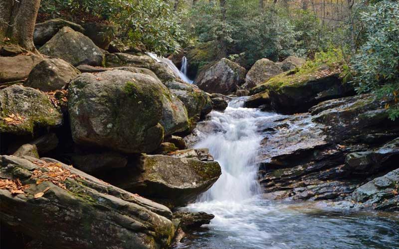
7. Catawba Falls Trail
- Waterfall Height: 100-feet
- Distance: 1.5-mile
- Level: Moderate
- Elevation Gain: 800-feet
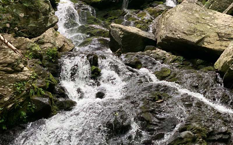
The headwaters of the Catawba River are beautifully scenic. Just east of Asheville, the river tumbles through a rolling forest, cascading in a series of waterfalls and flowing over a mossy riverbed set in a shady, scenic stretch of the Pisgah National Forest.
The 1.5-mile hike is a steady, slightly uphill walk but not difficult. On the trail, you will pass by stone foundations and a dam used for power generation in the early 1900s. Do not attempt to cross the dam, it is very dangerous. In 2012, the US Forest Service opened a parking lot and restrooms for the waterfall hiking fall in the Pisgah National Forest.
The US Forest Service has added two new footbridges so that you no longer have to hop across the river to enjoy the falls making this trail even more enjoyable. Deaths and injuries caused by hikers falling from the falls. Please do not climb the slick rocks in close vicinity of the falls.
Seasoned and skilled hikers can extend their adventure with a strenuous climb to the beautiful 50-foot Upper Falls. This is section is only recommended for expert climbers skilled at climbing rocks and steep mountainsides. The Forest Service plans to add a safer trail in the near future.
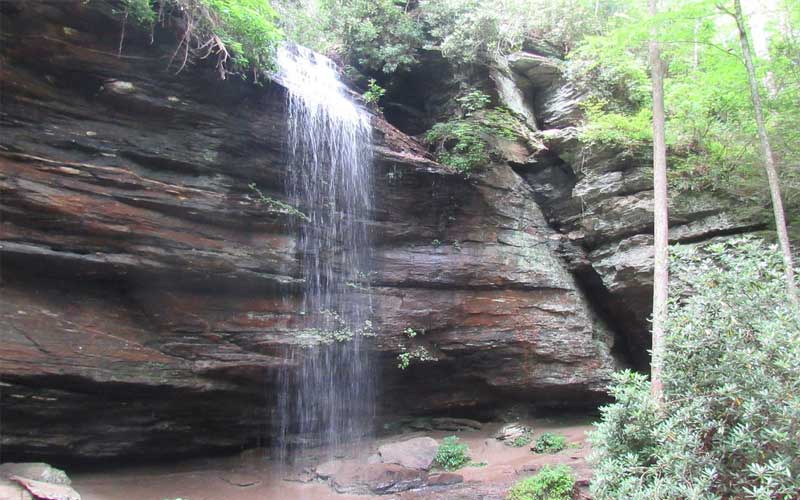
8. Dry Falls Trail
- Waterfall Height: 75-feet
- Distance: 0.25-mile roundtrip
- Level: Easy
- Elevation Gain: N/A

Dry Falls is a popular waterfall located just a few miles outside of Highlands. It gives you the rare treat of walking safely behind a waterfall. Dry Falls is 65-foot tall and plunges from an overhanging rock outcrop creating a beautiful white flowing water that falls on to the rocky riverbed below.
This waterfall hike probably qualifies as a short walk because it’s so short. The waterfall is exceptionally beautiful. There is a viewing platform at the trailhead, that is accessible for wheelchairs and strollers, offering great view of the falls.
The waterfall is literally right next to Highway 64 going towards Highlands, NC and requires just parking in the parking lot, and taking the very short walk to the observation deck, or walking down the very short walkway to and behind the actual falls.
The Dry Falls Parking area was redone fairly recently. It has been extended and brought on the same level as Highway 64. The steps down to the falls are at the west end of the parking area at the entrance to the wheelchair-accessible area. The walkaway needs some repairs so you need to be careful with your steps. You may be able to see a rainbow if you and the sun are in the right position.