8 Amazing Waterfall Hikes in Southern California
Southern California (also called SoCal) is not known for its waterfall hikes, still, there are some great waterfalls with impressive volumes of water. Its mild climate encourages outdoor activities all year. A beautiful waterfall isn’t far away no matter what your hiking ability is. The majority of these waterfall hikes are suitable for hikers of all skill levels. Below is the list of 8 amazing waterfalls I’ve been to in the state of California. All of these waterfalls require a hike, so plan accordingly. Bring plenty of water, a good pair of shoes, and a healthy dose of sunscreen.
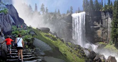
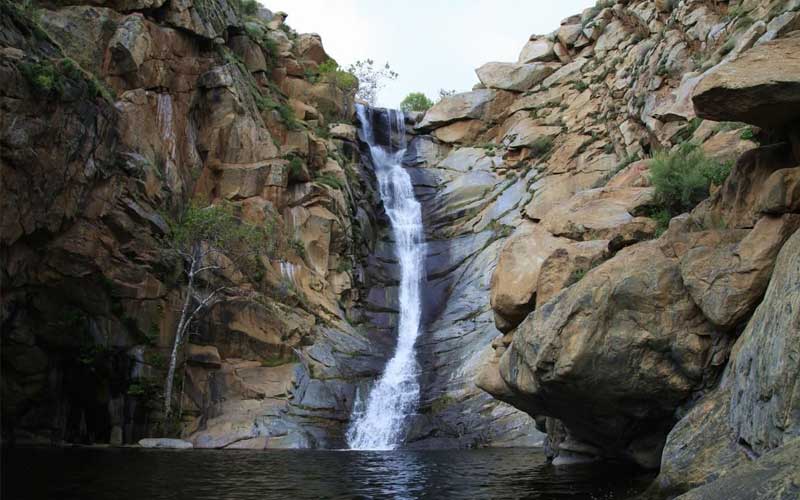
1. San Antonio Falls Trail
- Waterfall Height: 75 feet
- Distance: 1.3 miles
- Difficulty: Moderate
- Elevation Gain: 272 feet
- Location: Angeles National Forest
San Antonio is a 75-foot-tall waterfall that flows from Mount Baldy. It is one of the tallest and most easily accessible waterfalls in Southern California. Snowmelt increases the flow of San Antonio Falls in the early spring and late winter.
This is a simple hike, and those who are sensitive to altitude should have no trouble. While snow may fall during the winter, the majority of the route is on a paved service road, so the weather is unlikely to pose a hazard. Although getting to San Antonio Falls is simple, the long drive to Mount Baldy’s base is difficult. The majority of the hike is on a paved road. The pavement isn’t ideal for hiking, but Falls Road provides some nice views up San Antonio Canyon toward Mount Baldy.
If you want a strenuous hike after visiting the waterfall, you will find San Antonio Creek to be the perfect place to relax and rinse off. The cold and clean water beneath the waterfall is ideal for soaking tired feet. There is also an overlook with great views that makes for a great photo opportunity. The trail has some scrambling over boulders and narrow sections just before the falls, but it’s not too difficult. Because it is a short hike, it is not ideal for exercise, but it is a pleasant place to play in the water and have a picnic.
2. Cedar Creek Falls Trail
- Waterfall Height: 100 feet
- Distance: 4.9 miles
- Difficulty: Moderate
- Elevation Gain: 1000 feet
- Location: Cleveland National Forest
Cedar Creek Falls is one of San Diego County’s most beautiful waterfalls. It’s the bare rocks that surround the rocky oasis-like grotto into which the waterfall cascades that make it so appealing. Some impressive mountain scenery backs up the San Diego River basin, adding to the scenic appeal. The waterfall has become so popular in recent years that you now need a permit to do this hike. The waterfall is around 100 feet tall and falls into a large pool. This makes it very appealing to people who want to swim and spend time outdoors on hot summer days.
The falls can dry up without a lot of rain and the hike is very hot with no shade and a lot of uphill on the way back. That being said, if you go after a good rain, it’s not a waterfall adventure you’ll soon forget. With all of the water crossings and rock hopping to get back to its majestic waterfall.
There are two ways to get to the falls – the west entrance at the San Diego Country Estates accessed from Ramona and the east entrance at Saddleback Hill accessed from Julian. Both of these routes are of the same hiking distances of around 5 miles out and back. They’re both upside-down hikes. You go downhill to the falls then uphill back. Despite the two clearly marked trails and the lack of off-trail scrambling, this hike can be deceptively strenuous.
Bring a lot of water or a water filtration system because the hike itself is not too strenuous at only 1,000 feet of elevation gain, but the exposure and heat can make it tough if you go unprepared. There’s also an optional three-mile spur that takes you to the top of the falls. Save some water and energy for that last section as you will be doing a lot of uphills as you head out of the canyon.
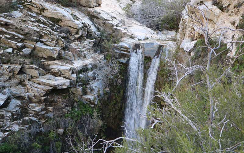
3. Escondido Falls Trail
Waterfall Height: 150 feet
Distance: 3.7 miles
Difficulty: Easy
Elevation Gain: 626 feet
Location: Escondido Canyon Park
Escondido Falls is located in Escondido Canyon Park near Malibu, California. It is a personal favorite of mine as the waterfall here is beautiful. The first mile of the hike is through a community, which is not particularly exciting. However, once you enter the canyon, you will leave the houses behind and cross several streams on your way to the falls. After a good rain, the falls here are really impressive, and while there is no large pool below, it is still worth visiting. I used to hike up to the upper waterfall as well, but that area is now private property, so it is no longer permitted.
The trail provides a variety of recreational opportunities and is open all year. You can bring dogs to use this trail but they must be kept on a leash. When the Falls is flowing strong, it is flat out one of the finest waterfalls in Malibu. Escondido Falls has a hard-to-reach upper tier that’s 150 feet tall and an easy-to-reach lower tier that is 50 feet tall. It is a 3.8-mile round trip hike and it begins just off Pacific Coast Highway and goes uphill for 0.75 miles along Winding Way. You hike mostly on a paved road that passes extravagant Malibu residences. The waterfall is well worth the hike’s unconventional start.
Lower Escondido Falls is a fitting destination for many hikers that can be reached with ease. For those who want a bit more and are willing to work for it, Upper Escondido Falls is three times as tall and ten times as beautiful. You can use the roots for support to make your way upward. A rope may be available to help with one portion of this steep section of the hike.
Upper Escondido Falls is simply breathtaking. The water pours over a wall of lush green moss and drops 150 feet before landing in a tranquil pool. Escondido Falls has a good flow of water, it is one of the best around. If you are prepared to get wet, this precarious venture adds even more fun to the hike.
4. Tangerine Falls Trail
- Waterfall Height: 100 feet
- Distance: 2.2 miles
- Difficulty: Hard
- Elevation Gain: 971 feet
- Location: Los Padres National Forest
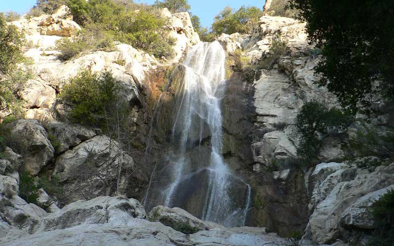
Tangerine Falls is located near Santa Barbara, California. The hike to Tangerine Falls is a 2.2-mile out-and-back trail that features a waterfall and is rated as difficult. The hike offers several activity options and is best used from March until November. Dogs are also able to use this trail but must be kept on a leash.
It is a seasonal waterfall that is dry for most of the year. However, after a good amount of rain, the Falls blooms into Santa Barbara’s most beautiful waterfall. Tangerine Falls is a 2.2-mile hike with everything a hiker could want: an exceptional waterfall, plenty of shade, a soothing creek, ocean views, and some off-trail rock hopping and scrambling.
The hike begins with a relatively easy uphill climb before forking and splitting off. The path to Tangerine Falls begins on the right. This section of the trail is a little challenging. It’s a little rocky, so some scrambling is required. Keep an eye out for poison oak! The majority of the trail is shaded, and the creek that runs through it is beautiful.
The silky waters slide down a pink and brown sandstone cliff face. Tangerine Falls also provides a great view down the canyon toward the Pacific, or more formally, West Fork Cold Springs Falls, before returning the way you came. Tangerine Falls hike does not require any fees or permits. So get out there and have fun!
5. Sturtevant Falls Trail
- Waterfall Height: 60 feet
- Distance: 3 miles
- Difficulty: Moderate
- Elevation Gain: 646 feet
- Location: Angeles National Forest
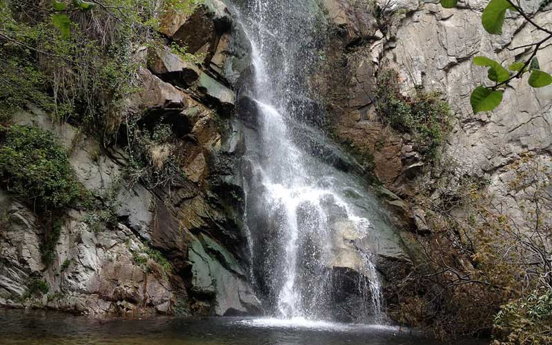
Santa Anita Canyon, located only 45 minutes from Los Angeles, is a popular destination with dozens of miles of trails and a couple of stunning waterfalls. The Sturtevant Falls Trail is a 3-mile round-trip hike through a beautiful canyon with lush forests and historic cabins. The trail is in Southern California, near Sierra Madre. It is the most visited waterfall in Los Angeles County. At the end of the trip, you’re greeted by a 60-foot waterfall that is impressive when it’s flowing.
While some of the other waterfalls on this list are seasonal, Sturtevant Falls is open all year but is most impressive in the spring. You can also extend your hike by going down to Hermit Falls, which is an equally impressive waterfall on the canyon’s south side. If you’re going to Hermit Falls first, don’t miss the five-minute spur that deviates from the main trail. Hermit Fall will add approximately two miles to your hike. You went about three miles to Sturtevant Falls and then added Hermit to make a five-mile round-trip. The Hermit Falls trail consists of gentle switchbacks through some lovely shaded areas.
6. Trail Canyon Falls
- Waterfall Height: 30 feet
- Distance: 4.8 miles
- Difficulty: Moderate
- Elevation Gain: 1053 feet
- Location: Angeles National Forest
Trail Canyon Falls is a 4.8-mile round-trip hike in the Sunland-Tujunga area of California. The approach to the waterfall on this hike is spectacular, so it deserves a spot on the list. After walking along a stream for 2 miles, you’ll begin to gain elevation as you ascend into the hills. When you round one of the hills, you’ll see Trail Canyon Falls right in front of you in the middle of the canyon, which is quite magical.
If you make it down the steep climb to the base of the waterfall, you’ll be greeted by a cascading flow that goes over the granite. This hike is somewhat more difficult than some of the others on the list but still easily accessible for most of the family. Most of the hike is a casual walk, the way in is nicely shaded until nearing the falls. You’ll experience most of the elevation gain near the falls.
Dogs are welcome to Trail Canyon Falls use but must be kept on a leash. The parking at the trailhead is free and the trail does not require any permit (a National Forest Adventure Pass is no longer required) so get out and enjoy!
7. Three Sisters Falls Trail
- Waterfall Height: 150 feet
- Distance: 4.2 miles
- Difficulty: Moderate
- Elevation Gain: 997 feet
- Location: Cleveland National Forest
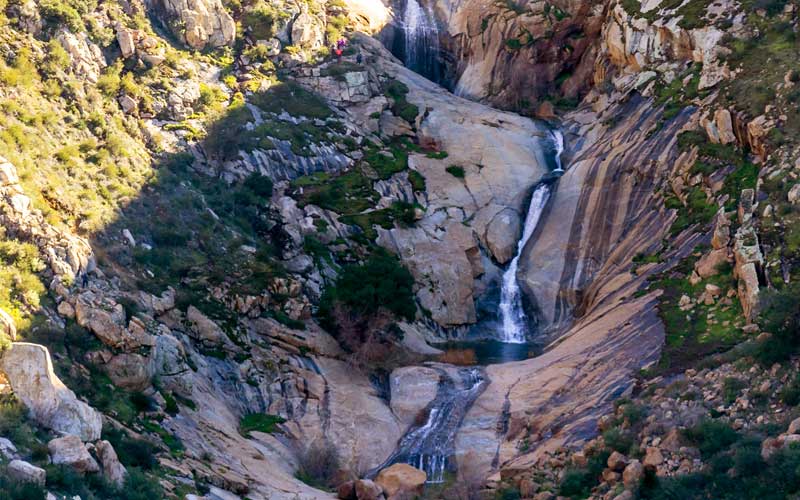
Three Sisters Falls is San Diego County’s most impressive waterfall. Many people will say that they like Cedar Creek Falls better but if you see the Three Sisters when it is flowing, it’s hard to think of a better waterfall in all of Southern California. This 4.2-mile is intense though which is why it is one of the last waterfalls on this list.
Three Sisters is near Julian, and just driving to the trailhead for the falls is an adventure. This is another hike that is mostly downhill, but once you get close to the waterfall, you’ll notice multiple tears that lead up into the canyon. If it’s flowing well, it’s an impressive waterfall to see because there are several waterfalls and many large pools into which the water flows. Again, there isn’t much shade here, so plan accordingly if you hike during the summer.
If you decide to go, you must take it slowly because the canyon is very steep. It’s just as difficult to climb back out as it is to climb up. The Three Sisters are three waterfalls, each with its own unique flow. The top waterfall is a more traditional waterfall, with water flowing directly into the pool below. The second and third waterfalls cascade over a long stretch of land, making them impressive but different from the top one. Also, it’s extremely popular on weekends, so try to go on a weekday if possible.
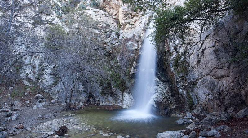
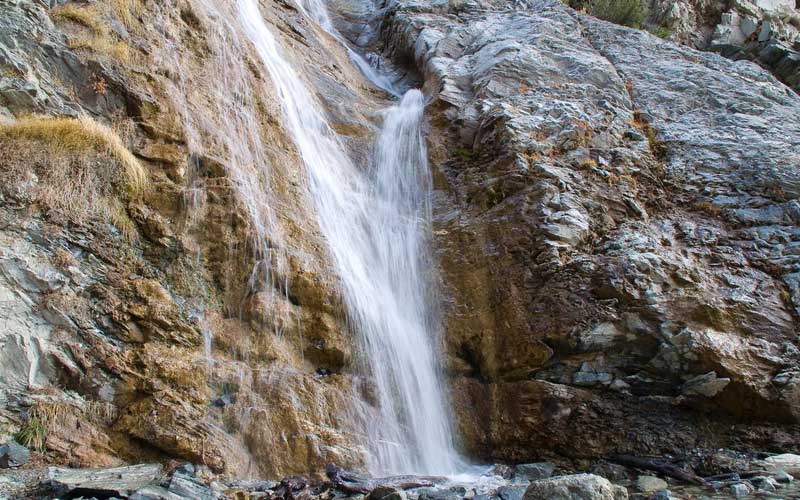
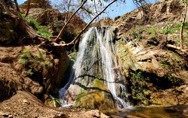
8. Black Star Canyon Falls Trail
- Waterfall Height: 45 feet
- Distance: 6.8 miles
- Difficulty: Moderate
- Elevation Gain: 941 feet
- Location: Cleveland National Forest
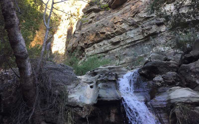
The final waterfall for this list is Black Star Canyon Falls in Orange County. Black Star Canyon Falls in Orange County is the final waterfall on this list. This is by far the most difficult hike on this list, measuring approximately 7 miles round-trip. A couple of those miles are painfully slow as you cross the stream over boulders while avoiding poison oak. There are many poison oaks, so bring long sleeves and hiking pants.
When you reach the 45-foot waterfall, you’ll understand why everyone is so excited. The water flows through a man-made cave, giving it that impressive appearance you’ve probably seen before. It’s also a pretty seasonal waterfall, so don’t go if it hasn’t rained recently.
The first half of this hike is relatively easy, but the second half is a rock and boulder scramble up to the falls along the stream bed of Black Star Canyon Creek. It’s doable and challenging; you’ll get dirty, and you might slip and slide a little, so be prepared.