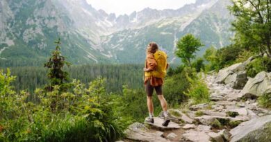
7 Hiking Trails in Arkansas with Waterfalls
Arkansas is home to some of the most spectacular waterfalls in the country. These waterfalls range from beautiful icons for springtime swimming to hidden gems for shady summer picnics. They also offer great spots to relax with the family. The state also boasts fascinating geology, such as caverns, sinkholes, towers, and grottos, located near many of its waterfalls. No matter what your skill level is, a gorgeous waterfall isn’t too far away. Additionally, Arkansas has some of the most beautiful national parks in the country. In this article, I will show you 7 of my favorite waterfalls in the state. So keep reading to learn more.
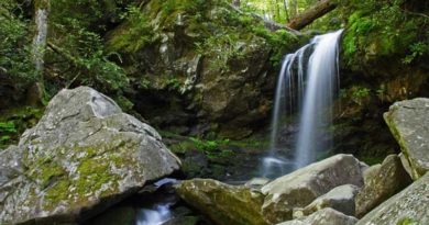
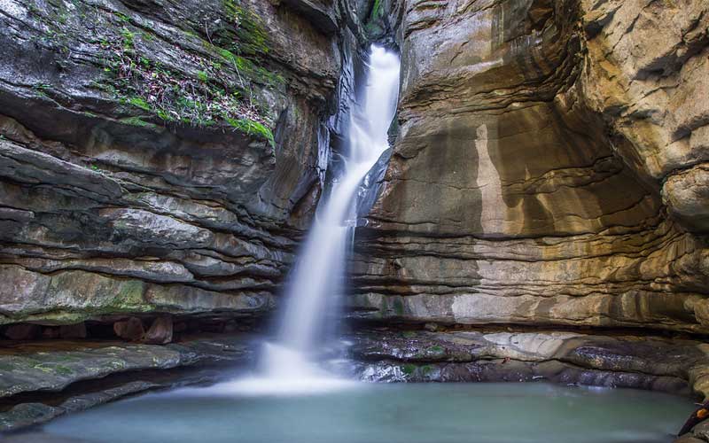
1. Pam’s Grotto Falls Trail
- Waterfall Height: 37 feet
- Distance: 0.8 mile
- Difficulty: Moderate
- Elevation Gain: 206 feet
- Location: Ozark National Forest
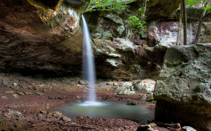
Pam’s Grotto is a year-round accessible 0.8-mile hike in Haw Creek Falls Recreation Area. It is a scenic waterfall trail used for hiking and rock climbing. This is a fun hike and you’ll experience some small but challenging rock scrambles to get to the actual grotto area. The first quarter-mile of the trail is pretty steep, but it levels off as you walk along the base of the rock bluff. The trail has some beautiful scenery so you won’t feel like you left completely empty-handed.
The trail is well-marked and when you get near the falls, you’ll be able to hug the wall on left and climb through a slightly dark area to the falls. If you like, you can go straight across the rocky area towards the falls. Both ways, you’ll end up right to the falls.
Getting to the trailhead can be challenging as the parking area is located half a mile east of the Haw Creek Falls Campground. To park your car, you can use the east side of the road. After parking, you need to cross the road to start the trail. Follow the marked trail uphill for a quarter-mile until you reach the bluffs. Turn left and continue for another quarter-mile with the bluffs on your right. You’ll hear the water flowing at the grotto soon. Take a short downhill path to see the waterfall up close. For the best view of Pam’s Grotto, visit after a decent amount of rain.
2. Glory Hole Falls Trail
- Waterfall Height: 31 feet
- Distance: 1.8 mile
- Difficulty: Moderate
- Elevation Gain: 387 feet
- Location: Ozark National Forest
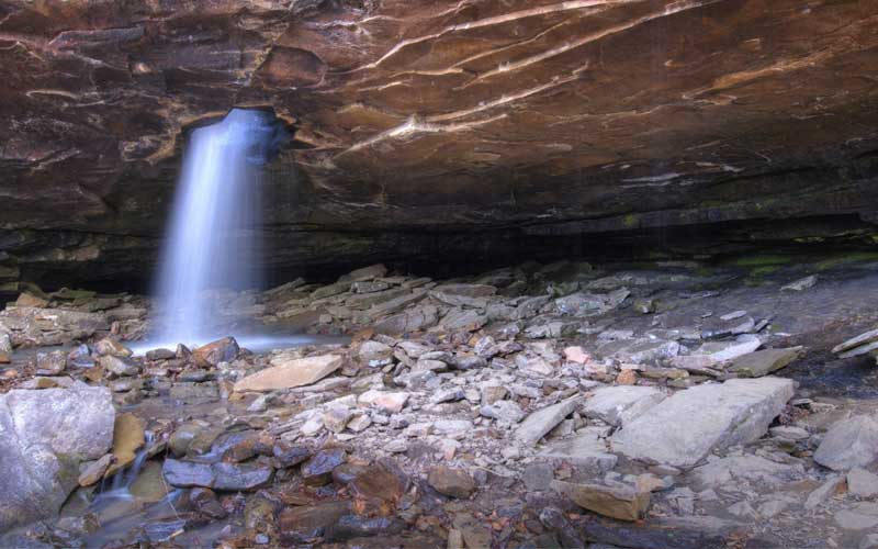
Glory Hole is one of the unique waterfalls in the Ozark area. Dismal Creek drilled a hole and the water falls from the hole into an overhanging cave bluff. The hike to the waterfall is short and adds to its spectacular appeal when water is falling. Although it’s mostly a trickle throughout the year, after a decent amount of rain, it becomes a spectacular sight. The waterfall is even more scenic when it becomes frozen in winter.
The waterfall is located between Fallsville and Edwards Junction, south of Boxley Valley. The trail is located in Newton County, in the Big Piney District of the Ozark National Forest. Although there is no official parking area or trailhead, the trail is well-maintained, primarily following old jeep roads. To reach the trailhead, look for a red barn on the north side of the road, approximately half a mile east of it. The trail is located on the south side of the road. You can use your GPS system to locate Cassville Baptist Church to easily find the trailhead.
Remember to plan a trip after a good rain or in the winter, because there’s a chance you’ll see frozen parts of the waterfall. There will be a short 387 feet elevation gain on your way back to the trailhead. However, the hike to the Glory Hole Falls is all downhill.
3. Cedar Falls Trail
Waterfall Height: 95 feet
Distance: 1.9 mile
Difficulty: Moderate to Strenuous
Elevation Gain: 367 feet
Location: Petit Jean State Park
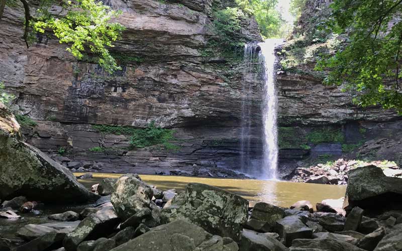
Cedar Falls is an impressive 95-foot tall waterfall that offers an amazing sight when it’s flowing well. Petit Jean is the first Arkansas state park and after a visit to Cedar Falls, it is easy to see why. The trail is particularly beautiful during wet times as Cedar Creek flows beautifully alongside it. You’ll also enjoy some really cool rock formations all along the trail.
The trail starts behind the Mather Lodge at Petit Jean State Park on Petit Jean Mountain, which is an attraction in itself. This trail is one of the most popular trails in the state, well-blazed and easy to follow. While the first part of the trail is moderately steep with uneven footing, it becomes easier once it levels off. You can cross the river by footbridge. Travel along the river for a while before going to the falls.
Once you reached the falls, take some time to enjoy the view and the soothing sound of the water. Keep in mind that swimming is not allowed. If you wish to get closer to the water, there is a trail to the right of the falls that crosses some large boulders. There is also a ledge behind the falls that you can climb up to. This part is strenuous. The key is to be in shape. Make sure to come prepared with proper footwear and a water filtration system.
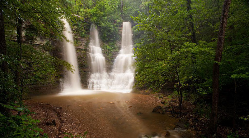
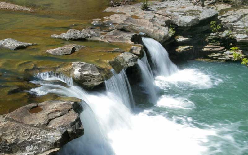
4. Triple Falls Trail
- Waterfall Height: 48 feet
- Distance: 0.3 mile
- Difficulty: Easy
- Elevation Gain: 9 feet
- Location: Buffalo National River Wilderness
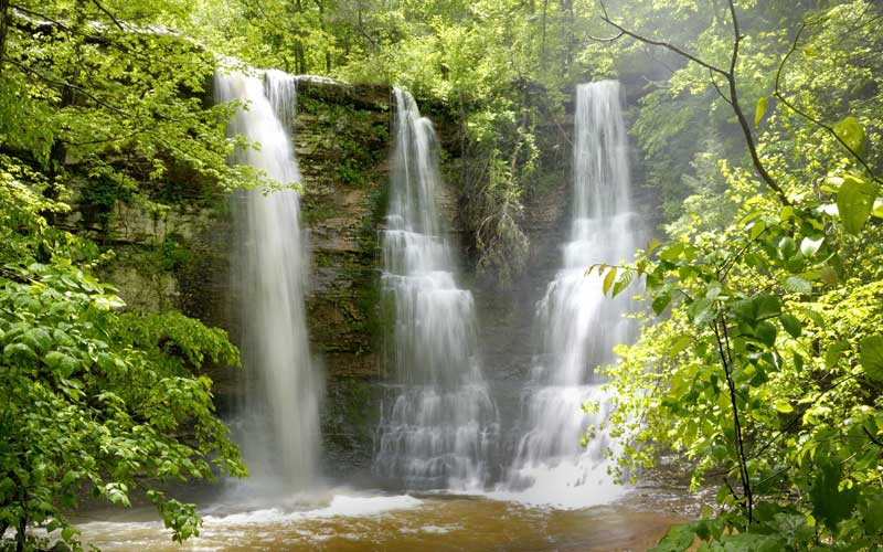
Triple Falls, also known as Twin Falls, is one of Arkansas’ most stunning and photographed waterfalls. Despite being named Twin Falls, it actually has three unique falls. You can find it at the Camp Orr Boy Scout Camp, south of Harrison, AR. Unlike other waterfalls in this area, Triple Falls flows throughout the year.
Getting to the falls is easy. This is a short, flat, 0.3-mile hike back to the falls. As you leave the parking area, head into the woods on the opposite side and follow the sign that directs you to Twin Falls. The trail begins with a little metal arch and leads you to one of the most stunning spots in the Buffalo River region. Take a seat and admire the picturesque view as the three falls cascade over the 48-foot ledge and into a serene pool below.
This is a must-see waterfall if you are in the area, preferably after a good rain. It features the most natural beauty for the least effort you will ever experience. If you’re willing to put in a bit more effort, you’ll be rewarded with an additional wonder from Rock Bridge Creek. Follow the road that crosses over Shop Creek and you’ll find another waterfall upstream that feeds into Triple Falls.
5. Thunder Canyon Falls Trail
Waterfall Height: 71 feet
Distance: 3.7 mile
Difficulty: Moderate
Elevation Gain: 328 feet
Location: Buffalo National River Wilderness
Thunder Canyon Falls Trail has become increasingly popular in recent years for good reason. It is an impressive waterfall that flows into a very nice slot canyon that makes it a little unique from most other waterfalls in the Buffalo National River Wilderness. The water crashing over the edge into the narrow gorge creates a thunderous sound, which is why it’s called Thunder Canyon Falls. With a name and a story like that, you know it’s going to be something special. So, plan to take your time when exploring this area, as there is plenty to see and do.
The trailhead for Thunder Canyon Falls is located at the Cecil Cove Loop in the Buffalo River area’s former community of Erbie. To reach Erbie, there are a few easy ways. The simplest route is to take Campground Road, which is about 3.3 miles north of Jasper off Highway 7. However, you will need to cross a low water bridge at the Buffalo River, which may not be safe during high water conditions. Another option is CR-19 from Compton, but it is an unmaintained, steep, and gravel road, and not recommended unless you have a 4WD vehicle.
Overall, this hike is rated moderate to difficult. Much of the way follows a relatively flat and maintained trail. However, there are multiple water crossings involved that make this hike somewhat challenging. The final half-mile includes slippery terrain that can be challenging even for the most sure-footed hikers.
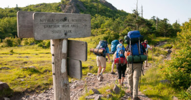
6. Hemmed-in-Hollow Falls Trail
Waterfall Height: 210 feet
Distance: 5.5 mile
Difficulty: Strenuous
Elevation Gain: 1400 feet
Location: Buffalo National River Wilderness
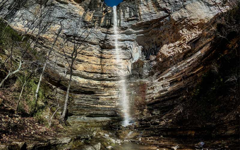
At 210 feet tall, Hemmed-in-Hollow Falls is the tallest waterfall between the Rocky Mountains and the Appalachian Mountains. This is a seasonal waterfall, which is nice when the water is high in the late winter and spring. However, it is only a 20-minute hike from the Buffalo National River but the hike isn’t very easy. It is popular among hikers and they’re eager to see this towering beauty of the falls.
While the hike to the Hemmed-in-Hollow Falls is in good condition, at 1,400 feet of elevation gain, the hike is not for the faint of heart. But a fantastic waterfall and secluded canyon await those who make the challenging 5.5-mile hike.
There are multiple ways to get to the waterfall. One comes in from the Center Point Trailhead and another comes in from Compton (a more direct route). You can also get there by floating the Buffalo River from Ponca, and then hiking back to the falls.
The surrounding area is absolutely breathtaking. So, take some photos and grab a snack here, as the hike back is a bit more challenging. With a little more effort, you can scramble up the right side of the falls to a ledge that wraps around the back of the waterfall. If you prefer, continue around to the north side of the falls and head west along the ridge. That’s where the rock is crumbly, so don’t free climb it. A lot of people have had their holds break off and taken nasty falls.
7. Kings River Falls Trail
- Waterfall Height: 10 feet
- Distance: 1.8 mile
- Difficulty: Easy
- Elevation Gain: 72 feet
- Location: Ozark National Forest
Kings River Falls is a relatively easy but scenic hike along the banks of the Kings River that ends at the falls. Particularly from mid-autumn to mid-spring, the scenery along the way is simply stunning. The trail is straightforward to navigate and is in excellent condition. As you make your way towards the falls, you’ll pass by remnants of an old rock stone fence. If you’re feeling adventurous, you can take a dip in the river beneath the falls. But be careful, there’s no lifeguard available.
rewrite this paragraph “The ponds are nice and fun for all ages. The water is cool even in the summer. But beware of water moccasin snakes. Otherwise, the swimming area is safe but do not go exploring under the waterfalls! It is a good hike if you plan on swimming at the end.
While the hike itself is great and suitable for all skill levels, there is a bit more to see here. There is a creek just upstream from the Falls that comes in from the trail side of the river. If you prefer, follow this little creek upstream a bit. There are also a series of waterfalls that come down off the top of the hill.
Overall, Kings River Falls is a great trail that has a little bit of everything. Rock formations, spots to explore by the river, and of course the falls. You’ll love how it follows the river the whole way. Get a good pair of footwear and be prepared for a rocky walk with some wet areas.